Trail Walking Le Sappey-en-Chartreuse - les Emeindras par les crêtes du St Eynard  - Photo

les Emeindras par les crêtes du St Eynard

 Coquet
Coquet

User

© OpenStreetMap contributors
Length
Length
13.5 km
Max alt
Max alt
1491 m
Uphill gradient
Uphill gradient
629 m
Km-Effort
Km-Effort  
22 km
Min alt
Min alt
1004 m
Downhill gradient
Downhill gradient
628 m
Boucle
Boucle
Yes
Creation date :
2023-07-17 13:46:17.378
Updated on :
2023-07-17 13:46:22.502

(1 Reviews)

Walking
Walking
4h58
Difficulty : Medium

Scan this QR Code to open this trail in the SityTrail application

FREE GPS app for hiking

Logo SityTrail SityTrail

IGN / Geographical institutes

Download SityTrail from the App Store Download SityTrail from Google Play

Logo SityTrail SityTrail World

The world is yours!

Download SityTrail from the App Store Download SityTrail from Google Play Download SityTrail on Huawei AppGallery

About

Trail Walking of 13.5 km to be discovered at Auvergne-Rhône-Alpes, Isère, Le Sappey-en-Chartreuse. This trail is proposed by Coquet.

Description

départ du Sappey en suivant la piste jusqu'à rejoindre le GR qu'on quitte rapidement pour suivre un sentier.

Elevation profile

Positioning

Country:
France
Region :
Auvergne-Rhône-Alpes
Department/Province :
Isère
Municipality :
Le Sappey-en-Chartreuse
Location:
Unknown
Start:(UTM)
718069 ; 5015390 (31T) N.

Comments

Please log in to post a review or rate the element


Trails nearby

Trail Walking Saint-Nazaire-les-Eymes - Chateau-Nardent par le C9 - Photo
Walking
GuyVachet

Walking

Difficult
(2)
Saint-Nazaire-les-Eymes, Auvergne-Rhône-Alpes, Isère, France
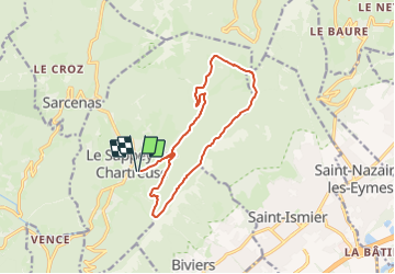
8.2 km | 17.7 km-effort
6h 23min
Yes
Trail Walking Corenc - Mont Saint-Eynard par le Pas Guiguet  - Photo
Walking
cmarit

Walking

Difficult
(2)
Corenc, Auvergne-Rhône-Alpes, Isère, France
10.9 km | 26 km-effort
6h 5min
Yes
Trail Walking Sarcenas - Chamechaude par le Jardin, depuis le Col de Porte - Photo
Walking
tracegps

Walking

Difficult
(2)
Sarcenas, Auvergne-Rhône-Alpes, Isère, France
10 km | 23 km-effort
6h 19min
Yes
Trail On foot Plateau-des-Petites-Roches - Tour de Pravouta - Photo
On foot
GUIDE+

On foot

Easy
Plateau-des-Petites-Roches, Auvergne-Rhône-Alpes, Isère, France
3.9 km | 7.5 km-effort
1h 42min
Yes
Trail Walking Plateau-des-Petites-Roches - Dent de Crolles - Photo
Walking
simon.paume

Walking

Difficult
(1)
Plateau-des-Petites-Roches, Auvergne-Rhône-Alpes, Isère, France
8.4 km | 18 km-effort
3h 40min
Yes
Trail Walking Sarcenas - la Pinéa du col de Portes - Photo
Walking
GUIDE
nadinebondoux

Walking

Difficult
Sarcenas, Auvergne-Rhône-Alpes, Isère, France
8.7 km | 14.4 km-effort
4h 41min
Yes
Trail Walking Saint-Pierre-de-Chartreuse - Circuit autour de Pravouta (Saint Hilaire du Touvet) - Photo
Walking
Jean-MarieFaux

Walking

Saint-Pierre-de-Chartreuse, Auvergne-Rhône-Alpes, Isère, France
4.3 km | 7.9 km-effort
2h 10min
Yes
Trail Touring skiing Proveysieux - 140124 Mont Fromage - Photo
Touring skiing
mzonzon05

Touring skiing

Easy
Proveysieux, Auvergne-Rhône-Alpes, Isère, France
8.5 km | 18 km-effort
3h 21min
Yes
Trail Walking Biviers - Cresancoche - Photo
Walking
NANE51

Walking

Easy
Biviers, Auvergne-Rhône-Alpes, Isère, France
3.3 km | 6.2 km-effort
1h 12min
Yes


Close
My subscriptions